
Watching Two Areas In Atlantic Basin


- Tropical development is possible late this week in the western Caribbean Sea.
- Regardless of development, heavy rainfall could push toward parts of the Caribbean.
- An area of low pressure off the Southeast Coast has a low chance for tropical development.
- November development during a strong El Niño is extremely rare.
Tropical development is possible late this week in the western Caribbean Sea, a rarity for November during a strong El Niño, and could bring flooding rain to Hispaniola, including Haiti. In addition, an area off the Southeast Coast has a low chance of tropical development.
What we’re watching: A cluster of showers and thunderstorms is percolating from north of Panama into the western Caribbean Sea east of Honduras and Nicaragua. Computer forecast models over the past several days have consistently hinted that an area of low pressure could form later this week in that general location east of central America and south of Jamaica.
A second area is also being monitored: An area of low pressure is expected to develop near South Florida in the next day or so. Development into a tropical cyclone is unlikely as it moves northeastward near the Bahamas and off the East Coast into this weekend. However, it will produce gusty winds and heavy rain.

Possible NHC Development
(The possible area(s) of tropical development according to the latest National Hurricane Center outlook are shown by polygons, color-coded by the chance of development over the next seven days. An “X” indicates the location of a current disturbance.
)
What could happen in the Caribbean: If hostile shearing winds remain low enough, and if thunderstorms can continue to coalesce near an area of low pressure over water that is still very warm, a tropical depression or storm could form sometime late this week in that area of the southwest Caribbean Sea. If it becomes a storm, it would be named “Vince”.
(Further beef up your forecast with our detailed, hour-by-hour breakdown for the next 8 days – only available on our Premium Pro experience.)

Satellite, Wind Shear, NHC Development Area
(Areas of clouds are shown in white. Areas of strong wind shear, the difference in wind speed and direction with height, are shown in purple. High wind shear is hostile to mature tropical cyclones and those trying to develop. An “X” indicates the location of a current disturbance the NHC is monitoring for development.
)
Where it could head: The system is expected to be pulled northeastward toward Jamaica, eastern Cuba and Hispaniola by Friday or Saturday, then into the southwest Atlantic Ocean by Sunday, where it is expected to transition to a non-tropical low. This will not be a threat to the mainland U.S.
What are the potential impacts: Regardless of whether this becomes a depression, storm, or remains a nameless area of low pressure, the potential for heavy rainfall appears to be the most serious threat from Jamaica and eastern Cuba to Haiti and the Dominican Republic late this week into the weekend.
This rain will be heaviest over hilly and mountainous terrain and will probably fall along and to the east of the system’s path, with lighter rainfall totals on the system’s western flank. Dangerous flash flooding and landslides are possible, particularly in Haiti.
Rip currents are possible later this week along south-facing shorelines of Jamaica, eastern Cuba, Haiti and the Dominican Republic. If this system becomes Tropical Storm Vince, some stronger wind gusts could add to the threat of downed trees in rain-soaked ground, and power outages.

Why this would be so unusual: As we’ve discussed before, November is still hurricane season, and typically generates a storm every 1 to 2 years. The western Caribbean Sea is one place that typically happens.
That’s much harder to do during a strong El Niño. As we discussed in a previous piece, plenty of wind shear and sinking air are usually in play over the Caribbean Sea this time of year that would squash any tropical development. That shear may not be strong enough to inhibit development this time.
In records dating to 1950, only three systems have previously become depressions or storms in November during a strong El Niño in the Atlantic Basin. As you can see in the track map below, none of those systems did so in the Caribbean Sea.
So, this could be a first for the tropical Atlantic in at least 73 years.
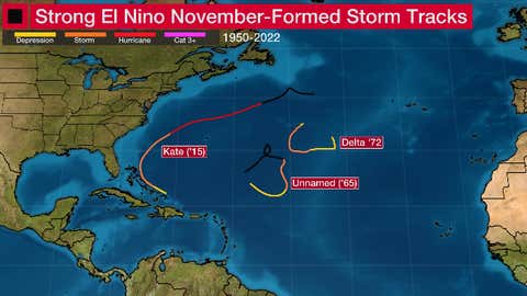
The tracks of systems that first became tropical or subtropical storms in November during a strong El Niño from 1950-2022.
(Data: NOAA/NHC)
Check back with us at weather.com for updates to this forecast in the days ahead.
MORE ON WEATHER.COM
- How The 2023 Atlantic Hurricane Season Measures Up
- A Typical November During A Stronger El Niño In The Tropics
- 6 Changes A Stronger El Niño Could Bring This Winter
- How El Niño Got Its Name
Jonathan Erdman is a senior meteorologist at weather.com and has been covering national and international weather since 1996. His lifelong love of meteorology began with a close encounter with a tornado as a child in Wisconsin. He studied physics at the University of Wisconsin-Madison, then completed his Master’s degree working with dual-polarization radar and lightning data at Colorado State University. Extreme and bizarre weather are his favorite topics. Reach out to him on X (formerly Twitter), Threads and Facebook.
The Weather Company’s primary journalistic mission is to report on breaking weather news, the environment and the importance of science to our lives. This story does not necessarily represent the position of our parent company, IBM.
Crédito: Link de origem

- Advertisement -
Comentários estão fechados.